

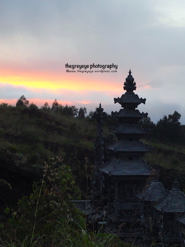
When in Bali, I heard from my friend Tejal, that we can go for a volcano trekking ! I immediately liked the idea because it is going to be my first volcano hike. So we booked the same cab as her and his name is “Ready “. Ready came to pick us up at 2.00 am in the morning, as we are staying in near Kuta. And the volcano is 80 km away. Ready is a good driver (Even his agency’s name is Good Bali drivers) and we reached little before 4 am. His price includes for the local guide, who is mandatory to accompany. Foolish thing was I did not take good shoes and I had to rent one along with a jacket. We bought some food, which was pretty expensive. Then we started our journey to the pick.


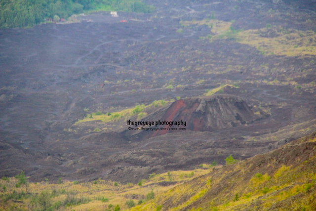
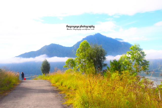
There are thousands of hikers and trekkers around but we kept falling back as my astrophysics nuts hubby keep taking picture of the southern hemisphere sky. The road is really tricky though because of the loose lava stones.Mount Batur (Gunung Batur) is an active volcano located at the center of two concentric calderas north west of Mount Agung on the island of Bali, Indonesia. The south east side of the larger 10×13 km caldera contains a caldera lake. The inner 7.5-kilometer-wide caldera, which was formed during emplacement of the Bali , has been dated at about 23,670 and 28,500 years ago. The most recent eruption was in 2000.


Crater summit is 1717 MT , but I did not go that far. My husband went up and I saw the sunrise from a midway resting place, but did not mind because the hike was harder near the top. Maybe next time 😛


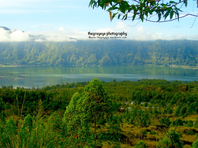


The caldera is populated and includes the four main villages of Kedisan, Songan, Trunyan and Toya Bungkah, among a total of 15 villages. The locals do lots of farming but many of the youngsters directly go to the guide business which is increasingly popular outdoor activity in Bali now.


©thegreyeye.wordpress.com, 2017-21. Unauthorized use and/or duplication of this material without express and written permission from this blog’s author and/or owner is strictly prohibited. All rights reserved.

Great post and photos!
Brought back memories of when I travelled through Indonesia back in 1998 – probably changed a lot since then. 🙂
LikeLiked by 2 people
Thanks Neela , hope your new adventures are going good
LikeLiked by 2 people
Yes, still in Italy until mid-October 2018 😉
LikeLiked by 2 people
Wow, are you in work visa or you do not need visa ?
LikeLiked by 2 people
I had to fly back to Australia last year and apply for a residency visa. Then on my return to Italy last October, I had to re-apply here, which gave me 2 years from last October. However, I am not allowed to work on this residency visa. Not sure if you read my very long post on my very long pain trying to get Italian Citizenship? https://imageearthtravel.com/2017/03/12/italian-citizenship/
LikeLiked by 1 person
ill check it out
LikeLiked by 1 person
Lovely photos and what an exhilarating hike! Bet you will remember this experience for a long time to come!
LikeLiked by 2 people
yeah i think so too 🙂
LikeLike
What an amazing day!! It seems like you were on top of the world! And the surrounding area is so lush and green– gorgeous! We lived in Costa Rica for a year and trekked up to a volcano’s edge– but it was pretty rocky and barren. Loved seeing your photos… thanks! xo
LikeLiked by 3 people
Thanks Rhonda, it must be amazing living in Costa rica
LikeLike
Hi!! It was a beautiful year– we made dear friends with a girl who helped with the kids. and loved the green countryside & the beaches!! Have you been to central America in all yoru travels?? xo
LikeLiked by 1 person
Nope , would love to go there
LikeLiked by 1 person
Beautiful photography. Awesome views.
LikeLiked by 1 person
Thank you 😊Bali is awes
LikeLike
Awesome *
LikeLike
Wow so beautiful, dear. Please visit our blog http://www.amazingbali.net there are so many info about beautiful places in Bali to explore 😉
LikeLiked by 1 person
Thank you! I think my next trip will be Bali so thank you for the useful information
LikeLiked by 2 people
U can see the related post: Bali tips . It ll be helpful
LikeLiked by 1 person
Thanks! Already done! Very useful
LikeLiked by 2 people
We hiked it and booked an Airbnb local camping tour you camp in a village go up the local side. It was extremely slippery and hard to hike. We started at 3 am and were supposed to be back down and at the hot springs by 9 I did not see how? We got up to the top around 6 ish. We are pretty experienced hikers but this was hard. I felt as though the experience was a little rushed. Get up to get back down. Wish I could have enjoyed it more. You took way better photos clear day it seemed
LikeLiked by 1 person